Tuesday, April 24, 2012

Oaks Bottom Wildlife Refuge - Portland, Oregon

Oaks Bottom Wildlife Refuge
2.8 mile loop | 100 ft elevation gain

Oregon Grape and Graffiti at Oaks Bottom Wildlife Refuge - Portland, Oregon 
Oaks Bottom: a smelly loop, half dirt - half bike path, around a shallow, swampy floodplain with scenery that includes a creepy, towering mausoleum/crematorium covered in animal murals, an amusement park/roller rink dating back to 1905, and the murky Willamette River. It is Portland's first wildlife refuge and migratory bird park, with over 185 bird species spotted within the refuge at one time or another. It also happens to be located on the edge of one of my favorite Portland neighborhoods, Sellwood.

A trip around Oaks Bottom is not a hike but a walk. Half of this walk is down a paved bike path that parallels railroad tracks. Here you are constantly at risk of getting murdered by a bicyclist, but all in keeping with the Portland spirit. The other half is on a dirt path with a bluff on one side and swampland on the other (see photo on left). Here you are constantly at risk of running into a group of hobos sitting by a campfire cooking beans, or at least so it seems.

Mausoleum / Crematorium as seen from the Oaks Bottom loop trail
You'll probably speed up your pace once you reach the mausoleum/crematorium. I'm not even remotely superstitious, but the place is sort of creepy, not to mention it looks like a Soviet apartment project.

Oaks Amusement Park
Throughout most of the hike you will hear children hooting and hollering (and screaming) while being whipped around on carnival rides at Portland's answer to Coney Island: Oaks Amusement Park. At the same time, you will smell a distinctly swamp-like, stagnant-pond-water smell. Odd but true, this is one of my favorite smells, solely for nostalgic reasons. It reminds me of the musty, murky ponds and lakes I visited as a kid in the Midwest, as well as those humid summer nights after a good hard rain. (But then again, having grown up in a small farm town, the smell of cow manure has the same nostalgic effect on me, so maybe it's best that you, reader, do not listen to a word I say about odors being pleasant or otherwise)

Oaks Bottom Wildlife Refuge as seen from the loop trail
Looking out over the Willamette River, I realized how much it reminded me of the river I grew up near: the Rock River in northern Illinois. In fact, the whole park reminded me of the Midwest. If I was kicking around Oaks Bottom and didn't know any better I would think I was in Chicago, Des Moines, Omaha, etc. All the quintessential pacific northwestern elements are missing from this park. Where are the mountains in the distance? Where are the doug firs? What are these oak trees doing here? What is that motorboat doing out there on the river? Where are the canoes and kayaks?

Motorboatin' on the Willamette River | Oaks Bottom Wildlife Refuge | Portland, Oregon
Sidewalk Art | Oaks Bottom
But it was the occasional sleeve-tatted hipster flying by me on a fixed gear bicycle that looked as though it was retrieved from a dumpster, as well as the giant bird mural on the side of the mausoleum reminding me of the infamous "put a bird on it" Portland maxim made famous by the IFC television show Portlandia, that at last made me realize where I was. Oaks Bottom may not look, feel, sound, or smell like other typical Portland area parks, notably Forest Park, Washington Park, Mt. Tabor, etc -but it is most certainly a Portland park.

Mausoleum? Put a bird on it.


Mausoleum / Crematorium covered in bird murals | Oaks Bottom Wildlife Refuge | Portland, Oregon
Side note:
Sellwood is one of Portland's neatest neighborhoods, I think. No, it isn't hipster and trendy like Alberta, Hawthorne, Belmont, Mississippi, Division, etc. And no, it isn't posh and spendy like Nob Hill or the Pearl. It is chiefly an antiquing district. It's quiet, historic, sophisticated without being pretentious, bookish, down-to-earth, residential, quaint, grown-up without being too stuffy.

If you're headed to Oaks Bottom save some time to explore Sellwood, especially 13th ave, its main strip. If its antiques you're looking for, this is one of the best spots in Portland (if not the best). If you're looking for one of the best cups of tea you'll ever have, stop at Tea Chai Te, located in an old red boxcar! If you're looking for a damn good Oregon microbrew look no further than the aptly named Oaks Bottom Public House, owned and operated by one of Portland's best brewers, New Old Lompoc. If you're looking for great food you have several Italian options including a Cena and Gino's, as well as one of Portland's highest rated Asian restaurants Jade Bistro, Teahouse and Patisserie. If you'd prefer something more decadent there is There are also some outstanding bicycle shops, coffee shops, and comfort-y food restaurants in the area.

Here are some photos from SE Portland's Oaks Bottom Wildlife Refuge.

Paved Bike Path | Oaks Bottom Wildlife Refuge | Portland, Oregon
Roller-rink at Oaks Amusement Park | Oaks Bottom | Portland, Oregon
Oaks Bottom Wildlife Refuge | Portland, Oregon


Friday, April 20, 2012

Hamilton Mountain - Columbia River Gorge

Hamilton Mountain
6.4 miles round-trip | 2,000 ft elevation gain

Hikers en route to the Hamilton Mountain summit - Columbia River Gorge
Having felt really good last weekend after hiking up to Angel's Rest, which was a little under 5 miles round trip and a climb of about 1,500 ft., I decided to push myself a little harder this weekend. I looked through my guidebooks for a hike that was roughly 6-8 miles round trip with an elevation gain of over 2,000 ft. My eye caught Hamilton Mountain in the Columbia Gorge at Beacon Rock State Park: over 6 miles round trip with a 2,000 ft gain in elevation. That'll work.

Now there are hikes and there are hikes.

A walk down a flat, dirt path in a state park is considered a hike, but a hike is something much greater. A hike is an adventure. A hike is something that takes great effort to achieve. Most, if not all, of the hikes that I have covered in this blog up to this point have been just that: hikes. Winter is not a time to attempt serious hikes for numerous safety reasons. But Hamilton Mountain is the first hike that I have covered in this blog. You actually have to be in relatively good physical shape to do it; and it actually feels like an adventure rather than a mere pleasurable walk in the woods. A hike should have an element of danger to it (if not a liberal dose of danger), it should make you exhausted by the end of the day, it should intimidate you mentally and push you physically, it should be a journey grand enough that your friends and family beg you to at least tell someone where you're going in case you get lost or injured.

So what makes Hamilton Mountain a hike? Three things.

1. It will intimidate you mentally:

Decisions, decisions... - Hamilton Mountain - Beacon Rock State Park - Columbia River Gorge
2. It has an element of danger to it:

Hamilton Mountain - Beacon Rock State Park - Columbia River Gorge
3. It is a steep hike and will definitely push you physically:

Hamilton Mountain - Beacon Rock State Park - Columbia River Gorge
Quick Note:
My hike to the top of Hamilton Mountain marks my second time at Beacon Rock State Park. About a month ago I completed two hikes at Beacon Rock State Park:
1) I hiked to the top of Beacon Rock itself;
2) I hiked the first leg of the Hamilton Mountain trail to Rodney Falls, as well as took the side trip to Little Beacon Rock.

I did a separate blog entry on both of these hikes. Click on either of the links below to view those previous entries from Beacon Rock State Park.

To view my previous hike of Beacon Rock itself, please click here.
To view my previous hike to Rodney Falls and Little Beacon Rock, please click here.


Alright, let's talk about the hike.

The trailhead is very readily accessible, located just up the hill via a campground road from the main Beacon Rock parking area. There is adequate parking, restrooms, water, a playground, and a rather scenic picnicking shelter. There are also a few massive fell old-growth trees within this park-like trailhead area, one of which nearly comes up to my shoulders on its side, the other marking the start of the Hamilton Mountain trail.

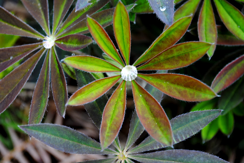
What on earth plant is this? I love it?
The first leg of the hike connects the trailhead with Rodney Falls. From the trailhead, you will primarily walk through a beautiful forest with moderate elevation gain. This is also where you'll find a beautiful and diverse array of flora. At one point early on you will emerge from the shaded forest into a sunny, wide-open slope that was cleared to make room for power lines, which you'll notice directly above you. The power lines aren't very sightly, but at least this clearing gives you a glimpse of Hamilton Mountain itself high off in the distance. "I'm going to climb to the top of that!?!?!" you might say. But do not worry too much, you do not have to be an avid hiker or athlete to make it to the top, but you will need a little will and persistence at the very least. If you're totally out of shape, you might need a little more.

Bridge over Rodney Falls
After the power lines you'll again enter the forest with just a short distance remaining before Rodney Falls. Before you get to Rodney Falls, you will actually come across Hardy Falls (easier to hear than see), with a muddy side trail leading to a view point. Don't expect much from the viewpoint- Rodney Falls is much more exciting, as well as a mere a hop, skip, and jump ahead of you. Rodney Falls, while far from the most impressive waterfall in the Columbia Gorge, is very beautiful. The rustic bridge at the foot of the falls only adds to the aesthetics. For a truly unique, if not intimidating, experience, climb up to the ledge and peer over the railing into the Pool of Winds. What is Pool of WInds? Basically, the first half of the falls dumps into this big rocky teacup with a notch cut into it, and the second half of the falls thunderously gushes out of said notch. It has that sort of "wrathful side of mother nature" appeal to it.

Here are some photos of the first leg of the hike, from the trailhead to Rodney Falls.

Hamilton Mountain - Beacon Rock State Park - Columbia River Gorge
Hikers crossing at Rodney Falls - Hamilton Mountain - Beacon Rock State Park - Columbia River Gorge
The second leg of the hike begins at the far side of the bridge over Hardy Creek at the foot of Rodney Falls and ends at a gnarly lookout over the Columbia River.

The area around Rodney Falls, unsurprisingly, can get very muddy. The stairs leading up from the falls to Hamilton Mountain are no exception.

The stairs leading from Rodney Falls to Hamilton Mtn Trail
Shortly after climbing the stairs and wandering through some more beautiful forest, you'll come to a fork in the road and a sign that gives you two options: Difficult and More Difficult (see above) Take the more difficult path to the left. It is way more scenic. At this point you'll notice the hike get steeper, your layers coming off one by one, your lungs working hard, and your legs working harder. You're about to get a work out, yes, but don't worry, you're not about to climb Mt. Everest or anything. It isn't that bad.


"The Rocky Thumb"
After climbing steep switchbacks you'll emerge out into the open at what I think is the highlight of the whole hike (yes, even more so than the summit itself)- a large rocky "thumb" poking out into the gorge. The views from here are great and the "thumb" itself has a few short paths on it that lead to even better views. There is a huge, jagged crevasse with vertical drops here, so use extra caution and do not get too close to the edge. There is already one little gravestone placed upon these rocks here, and a fall in this area would be very bad. Enjoy the views but use caution.

Here are some photos of the second leg of the hike, from Rodney Falls to the rocky "thumb."

Hamilton Mountain - Beacon Rock State Park - Columbia River Gorge
Beacon Rock  in the distance - Hamilton Mountain - Beacon Rock State Park - Columbia River Gorge
Hamilton Mountain - Beacon Rock State Park - Columbia River Gorge
"The rocky Thumb" - Hamilton Mountain - Beacon Rock State Park - Columbia River Gorge
View from "the Rocky Thumb" - Hamilton Mountain - Beacon Rock State Park - Columbia River Gorge
The third and final leg takes you from what I have dubbed "the rocky thumb" to Hamilton Mtn's summit 2,438 ft above the Columbia River.A short ways after the rocky thumb you will find yourself out in the wide-open switching-back steeply with a wonderful view of Beacon Rock off in the distance (from here it looks tiny... really makes you realize just how high up you are). Use caution in this area too- there is a straight-drop off a cliff in this switchback area and the ground upon which you walk is gravely and can be slippery. This wide-open space with the switchbacks is one of my favorite parts of the hike.

Hamilton Mountain - Beacon Rock State Park - Columbia River Gorge
After leaving the wide-open space and re-entering the shady forest, you'll be glad to know that you're nearly there. The remaining climb is steep (see below) but there isn't much climb left.

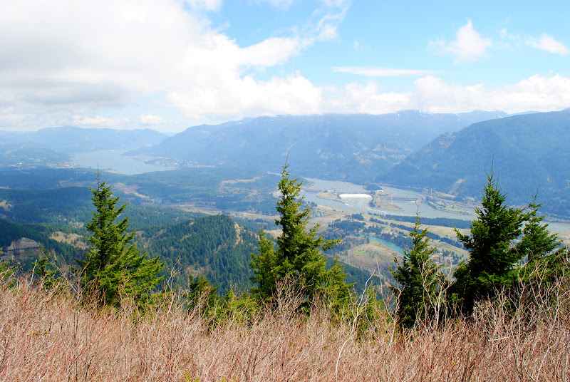
The view from Hamilton Mountain's summit is grand. On a clear day you'll see Mt. Adams looming out in the distance, Bonneville Dam and Cascade Locks far down below, and the much taller Table Mountain just a "stone's throw" to the east. After climbing Hamilton Mountain  -standing at the summit, huffing and puffing and tired- it is hard to fathom climbing Table Mountain, which doesn't exactly dwarf Hamilton but is, imposingly, much taller.

After having hiked to Angel's Rest last weekend, I came to the conclusion that Hamilton Mountain's summit has a great view, but that's about it. Do not climb up here expecting Angel's Rest: boulders to climb on, a variety of places to pop a squat and have a picnic, hell, even room to lay a blanket down without getting in other people's way.

The summit area itself is very small and narrow- sort of like a T-intersection that is surrounded on all sides by thick brush. The area in which to take a load off is really no wider than a hiking trail, so be respectful when you're up here- share this area with the others who've made the trek. Have a snack, take a few liberal swigs from your water bottle, savor the view for a while, and then try to convince your tired, wobbly legs that it's time to head back down.

Here are some photos of the third leg of the hike, from  "the rocky thumb" to the 2,438 ft summit.

Hamilton Mountain - Beacon Rock State Park - Columbia River Gorge
Beacon Rock a dwarf in the Distance - Hamilton Mountain - Beacon Rock State Park - Columbia River Gorge
The view from the Hamilton Mountain trail - Beacon Rock State Park - Columbia River Gorge
A hiker taking a photo from the cliff- Hamilton Mountain - Beacon Rock State Park - Columbia River Gorge
Table Mtn. and Mt. Adams (both summits covered by cloud-cover) - view from Hamilton Mtn. summit
View from Hamilton Mtn. summit
Bonneville Dam from Hamilton Mtn summit 2,438 ft above (full zoom on camera)
Needless to say, after hiking Hamilton Mountain I was exhausted. I wanted a burger and an IPA like it was nobody's business. I remembered passing by a restaurant called the Pacific Crest Trail Pub in Cascade Locks, so I made that my next destination shortly after returning to my automobile..

Burger with Tillamook cheddar and a Walking Man I.P.A. at Pacific Crest Trail Pub in Cascade Locks, Oregon
McMenamins Greater Trumps - Hawthorne District - Portland, Oregon
Ok, ok. I'm not going to lie. Hamilton Mountain has been my most strenuous hike since starting this blog. I wanted to chill afterwards. I drove home, showered, changed, and quickly ended up at one of my favorite cigar bars in Portland: McMenamin's Greater Trumps.  Next door to the legendary Bagdad Theater in the Hawthorne District, Greater Trumps is what you would probably call a "hole in the wall" (because that is essentially what it is) but it is a philosophical, literary, aficionado, jazzy, port-wine-or-fine-whisky-lover's-den if there ever was one in Portland. I frankly love it here. An hour at Greater Trumps, with a Perdomo and a glass of homemade I.P.A., served as a most relaxing end to a tiring day.

McMenamins Greater Trumps - Hawthorne District - Portland, Oregon
McMenamins Greater Trumps, a Perdomo Lot 23 torpedo, A History of the World in 10 1/2 Chapters by Julian Barnes, and a cold glass of McMenamins own I.P.A.:

McMenamins Greater Trumps | Perdomo Lot 23 | Pint of I.P.A. | A History of the World in 10 1/2 Chapters
I love this city...

Thursday, April 12, 2012

Angel's Rest - Columbia River Gorge

Angel's Rest
4.6 miles round trip | 1500 ft elevation gain

Angel's Rest - Columbia River Gorge
Columbia River from Angel's Rest
Angel's Rest: one of the most popular and crowded hikes in the Columbia River Gorge. It is so crowded, in fact, that one of my guide books states that on any given summer weekend you'll likely see more dogs on Angel's Rest than you will hikers on many other gorge trails. It also took me a good twenty minutes of illegal u-turns on the Historic Columbia River Highway to finally find a parking spot near the trailhead. But then again, I arrived shortly after noon- not a good time to find a parking spot anywhere in the gorge on the first dry, sunny Saturday of the year.

But, in my opinion, there are three really good reasons as to why the Angel's Rest hike merits the crowds that it draws weekend after weekend.

First, Angel's Rest is one of the closest "great gorge hikes" to the greater Portland Metropolitan area. It is only 28 miles from downtown Portland (or, about 15 miles east of the metropolitan area city limits) via interstate 84; and the trailhead is a stone's throw from the interstate exit. Literally.

Second, Angel's Rest is a moderate hike with a great reward at the end- therefore it has a wide appeal. You will get a workout on this hike but you don't have to be an athlete to do it. The climb is gradual enough for families with children or those out-of-shape, but also enough exercise to please your habitual hiker. And the reward at the end: the view! Most hikes that lead to panoramic views like the one you'll experience high above the river at Angel's Rest are significantly more difficult and harder to get to, which of course limits the appeal of the hike to the masses (but greatly reduces the crowds). Some of those views come at the cost of extremely steep hikes that exceed 6 miles round trip. But Angel's Rest won't kill you; and the reward you get at the end of this hike is well worth the moderate effort you'll put into it. The view from Angel's Rest is amazing, but there's something that makes it even more amazing...

Third, think of Angel's Rest as a big rocky park / natural jungle-gym. Right before you reach the summit, the trail traverses a rock slide. Chances are you'll see groups of friends lounging on the rocks, conversing, laughing, just straight up hanging out 1,600 feet above the river. That's only the start of it. Keep going just a little further to the summit and you'll see the same thing and more. People sunbathing, couples posing cheek to cheek for photos, families picnicking, thrill seekers bouldering, teenagers texting, hipsters sitting indian-style writing poetry into little beat-up leather journals, you name it. You will feel as though you are in a city park, only you're not- you are at least fifteen miles away from the closest city and you had to break a sweat hiking about two and a half miles just to get here. It left me feeling really quite grateful to have a place to hang out that is this magnificent and unique. Rather than hanging out at home on such a beautiful day, various groups of Portlanders migrate to Angel's Rest to do the exact same thing they'd do in their backyards or front porches! If there is one thing Portlanders do exceedingly well it is loiter outdoors; and Angel's Rest is like the holy land for outdoor loiterers.

Without a doubt my next trip to Angel's Rest will include the intent of spending a few hours loitering at the summit with, hopefully, a picnic, my wife, and some friends. Or at the very least a good book and some beef jerky...

Unlike most blog entries, where I begin at the beginning and work my way to the end, with Angel's Rest I want to start at the end. Here are photos taken around the summit area of Angel's Rest and the rock slide.

Lounging around on the Rock Slide just below the summit of Angel's Rest
Angel's Rest - Columbia River Gorge
The view from Angel's Rest in the Columbia River Gorge and some hikers living on the edge
Now that you've seen the end, let me show you the means to that end: the hike itself.


The trailhead is located just off Interstate 84 at exit 28. There is a paved parking lot, but that fills up very quickly. If you arrive to this trailhead after about 10 a.m. on a weekend during spring, summer, or fall, expect to parallel park on the road or use the second "spill-over" parking area located not far from the main parking area.

Throughout the hike itself you will experience a few different kinds of forest. Right away, you will experience a very typical Northwest forest of tall mossy trees, ferns, and little white trillium blossoms.

The first leg of the Angel's Rest Trail - Columbia River Gorge
Trillium - Angel's Rest - Columbia River Gorge
Angel's Rest - Columbia River Gorge
Shortly after passing a view of Coopey Falls and the bridge over Coopey Creek, you will enter into a different kind of forest. This forest burned in a wildfire in the early 1990's, and you will notice that the forest here feels much more "second-growth" than the old-growth forest you just hiked through. Also, you'll start to notice some blackened trees, some of them dead, some alive, that survived the wildfire. One thing you will also notice is that it gets a lot sunnier and warmer through this younger, shorter forest. You will, however, still hit a few more patches of tall, shady, old-growth forest that was spared by the fire along the way.

The second leg of Angel's Rest trail - notice the blackened, dead trees to the left that burned in the 1991 fire
Angel's Rest - Columbia River Gorge
At around the half-way point you will round a corner to the right and get a glimpse of Angel's Rest's rocky summit above in the distance. At this point the forest will change yet again. The hike becomes a lot drier, open, and sunnier, which feels more like hiking in Southern California than Western Oregon. You will likely start to notice more and more of the blackened tree trunks mentioned above too. The hike emerges out of the forest and becomes a walk along a ledge with many switchbacks. You will also begin hiking among a thick brush and the bare, pointed tops of trees that survived the fire. At this point you will start to get great views of the Columbia far below, but don't stop and admire the views yet, they get much much better at the top.

The third leg of Angel's Rest Trail - Columbia River Gorge
Angel's Rest - Columbia River Gorge
Once you hit the rock slide (and trust me, you'll know it when you get there) you are almost to the summit. As much as you'll want to stop and take a load off for a moment I wouldn't recommend it. Keep going, you're almost there; and the summit has more than enough places to sit, relax, enjoy the view, converse, contemplate, climb around, eat lunch- whatever floats your boat.

Path through the Rock Slide - Angel's Rest - Columbia River Gorge - an adventurous Portlander's loitering spot
Once you get to the summit you have entered a huge natural park/playground. Have fun, relax, take a load off, have a picnic- as long as it's legal and respectful to your fellow hikers, do whatever you want up here! I only recommend two things: 1) if you're climbing on the rocks please be careful: it's a long, deadly way down if you were to fall in some areas. There is a big difference between being adventurous and being stupid; 2) take your time up on Angel's Rest- don't be in a huge hurry to get back to your car. Savor the time you have up here.

If you're a local, be thankful that you have the option of doing something this extraordinary on any given weekend- having grown up in rural Illinois myself, I can safely say that the majority of Americans may get the chance once or twice (if that) in their lives to experience something similar to this, but we locals can do this every weekend if we so desired. I, for one, felt the need to live in an environment that gave me the ability to experience outdoor adventures like this, hence why I now call Portland home.

Plenty of perilous photo opportunities at Angel's Rest - Columbia River Gorge
Now, from the summit of Angel's Rest you have three options: 1) return the way you came back down to your car; 2) continue on to Wahclella Falls (which I'd only recommend doing if you had another car parked down at Wahclella- a round trip would be quite a draining hike); or 3) continue on to Devil's Rest. If you continue on to Devil's Rest be prepared to climb some more, as you'll gain another 700 ft, roughly, of elevation. But, the hike to Devil's Rest has the advantage of being significantly less crowded. Curious to compare Devil's Rest to Angel's Rest, I decided to make the extra effort and continue on, albeit unsuccessfully.

Why unsuccessfully?

Well, my old Teva hiking boots blew out completely after my hike of Coyote Wall a few weekends ago. The tread, already loosening from lots of hiking wear, had finally begun to completely separate itself from the rest of the shoe. Knowing that I could use a new pair of hiking footwear anyway, I decided to lay the Tevas to rest and get a new pair, ultimately deciding on an extremely comfortable, very breathable, non-water-resistant pair of Vasque trail runners. These are dry/warm-season shoes. I can actually feel a breeze through the tops of them. When nearing Devil's Rest, I came to a point where I came across patches of snow. Then more snow. Then ultimately, the trail itself cut through wet, slushy snow with only a few boot tracks imbedded into it.

Not wanting to deal with wet feet for the remainder of the day, and realizing that Devil's Rest was not going anywhere, I decided to save my trek to Devil's Rest for another day, pulled a 180 in the snow, and started back the way I came. I will say this, however: the trail to Devil's Rest was beautiful. It was starkly different than the main Angel's Rest trail in that I did not meet a single other hiker the entire time I spent on the trail. It was the first time I had experienced sheer solitude and silence all day. And the forest that you walk through is magnificent, mossy old-growth with a soft, pine-needle floor. Even if you don't make it all the way to Devil's Rest, a quick side trip up into this area from Angel's Rest is highly recommended, if only to escape the crowds and noise momentarily and enter a beautiful old forest.

The following photos are of the path that joins Angel's Rest to Devil's Rest, ending at my snowy final destination for today's hike. Don't you worry, reader, I will be back one day in the near future to photograph Devil's Rest.

The woods from Angel's Rest to Devil's Rest - Columbia River Gorge
Snow on trail to Devil's Rest- Columbia River Gorge